Curry County Commissioner Court Boice told residents not to use profanity during the meeting, but said he wanted answers. “It was only by the grace of God we didn’t lose Brookings,” he said. “The loss is frankly incalculable and we want our government to tell us what happened.”
June
On June 17 I was still trying to wrap my mind around the details of London's horrific June 14 Grenfell Tower fire when news came of a wind-driven wildfire in central Portugal that killed at least 60 people, many of whom died in their cars in a futile attempt to drive faster than the firestorm.
By June 18 reports were coming in about an outbreak of several wildfires in Canada's British Columbia province, blown by winds so strong the flames could leap a mile-wide river.
In September, when 158 of the wildfires were still burning, Wikipedia summed the conflagrations:
The 2017 fire season is notable for three reasons; first, for the largest total area burnt in a fire season in recorded history; second, for the largest number of total evacuees in a fire season; and third, for the largest single fire ever in British Columbia.July
By July 9 NPR was reporting that wind-driven wildfires in California were forcing large evacuations and that 5,000 firefighters had been mustered to fight the blazes.
On July 10 The New York Times reported that wildfires, driven by high winds blowing in regions of bone-dry humidity and triple-digit temperatures, were raging across six western U.S. states.
Meanwhile in Europe
On July 19 Sky News reported that huge wildfires, fueled by unusually hot, dry weather and strong winds, were burning across parts of central and southern Europe as thousands of firefighters fought blazes ranging across five countries.
By July 26 the BBC was reporting that fast-moving wildfires were forcing the evacuation of 10,000 people in southeastern France during the height of tourist season.
Back in the USA
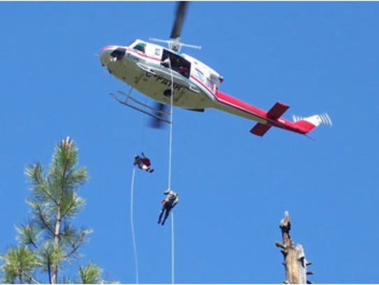
(Brookings, Oregon - The Statesman Journal - September) On the afternoon of July 12, four firefighters dropped from a helicopter into southwest Oregon’s Kalmiopsis Wilderness to try and snuff out a small but challenging wildfire.
The blaze was just a half-acre, but it was located on a mountain so steep that flaming logs and brush were already careening downhill to the Chetco River.
For two days, the team looked to attack the fire in deep brush, belly-crawling and bushwhacking along slopes as three helicopters dropped water on the flames, a U.S. Forest Service report said.
Eventually, they were forced to pull out.
“There were no escape routes, and the fire was dropping a shotgun pattern of spot fires down the hill,” said Monty Edwards, fire management officer for Rogue River-Siskiyou National Forest during a public meeting Thursday in Brookings.
“Somebody was going to get hurt if we stayed engaged in there.”
That day in early July would mark the beginning of the Chetco Bar Fire, a blaze that remained quiet for almost a month before exploding into the nation’s most dangerous wildfire.
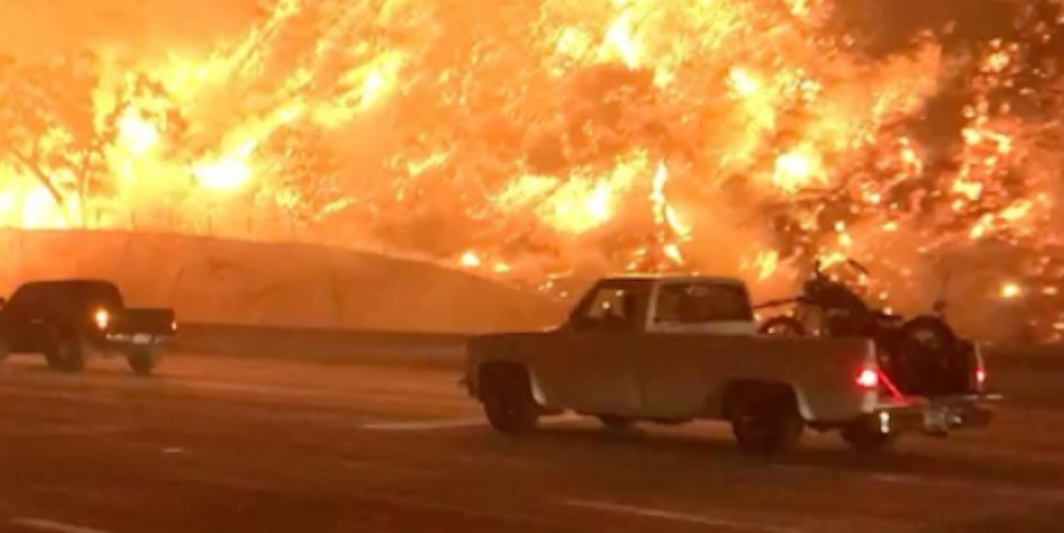
Chetco Bar would torch 190,000 acres, burn six houses, force 5,000 people to evacuate their homes and threaten communities from Brookings to Cave Junction.
The fire, now almost entirely contained following autumn rains, has cost $61 million.
At a tense meeting Thursday, Forest Service officials explained decisions they made in fighting the fire to a skeptical crowd.
Brookings resident Cecelia Worlton spoke of her home burning to the ground and getting no help to save it. Harry Harns said the Forest Service stood by as the fire grew and had learned nothing from past megafires in the same area.
Curry County Commissioner Court Boice told residents not to use profanity during the meeting, but said he wanted answers.
“It was only by the grace of God we didn’t lose Brookings,” he said. “The loss is frankly incalculable and we want our government to tell us what happened.”
[...]August
On August 13 the National Hurricane Center (NHC) began monitoring a tropical wave on the western coast of Africa. Amid favorable environmental conditions, the wave was expected to merge with a broad area of low pressure to its east southwest of Cape Verde and gradually organize. Instead, the two disturbances remained separate, with the broad trough continuing westward and the tropical wave moving farther north, eventually becoming Potential Tropical Cyclone Ten.
On August 17 shower and thunderstorm activity in association with the trough began to show signs of organization, while high-resolution satellite showed an increasingly defined low-level circulation.
In response the NHC initiated advisories on a potential tropical cyclone, allowing tropical storm watches and warnings to be hoisted for portions of the Lesser Antilles. An Air Force Reserve Hurricane Hunter aircraft deployed to the disturbance later that afternoon found a well-defined center and tropical storm-force winds, prompting the NHC to upgrade it to Tropical Storm Harvey at 21:00 UTC.Thus, Wikipedia's description of the genesis of Hurricane Harvey. If later hurricanes this year did more damage in terms of their range, Harvey was the strangest storm to visit coastal America in many a year if not in all of American recorded history.
After gathering all that power, the hurricane decided to dawdle when it came to Houston, hugging the coast so closely it could keep one toe in the coastal waters, as one observer put it, which allowed the hurricane to keep drawing energy from the bathtub-temperature waters.
But as the hours wore on, meteorologists noted with a mixture of awe and horror that Harvey was standing so still it was becoming self-sustaining -- literally making its own weather system.
By the time Harvey meandered away from Houston, Wikipedia would report:
Many locations in the Houston metropolitan area observed at least 30 in (76 cm) of precipitation, with a maximum of 64.58 in (164.0 cm) in Nederland. This makes Harvey the wettest tropical cyclone on record for both Texas and the United States, surpassing the previous rainfall record held by Tropical Storm Amelia.
The local National Weather Service office in Houston observed all-time record daily rainfall accumulations on both August 26 and 27, measured at 14.4 in (37 cm) and 16.08 in (40.8 cm) respectively.Back in the Atlantic Ocean
On August 30 Hurricane Irma was born, astoundingly growing within 24 hours from a tropical wave event into a Category 2 hurricane.
September
By September 6 Irma was a Category 5 hurricane. From Wikipedia's article on the storm, "Irma caused widespread and catastrophic damage throughout its long lifetime, particularly in parts of the northeastern Caribbean and the Florida Keys." And from its article on the 2017 hurricane season, "Irma was the strongest hurricane ever recorded to form in the Atlantic Ocean outside of the Gulf of Mexico and Caribbean Sea."
On September 16 a third major hurricane formed in the Atlantic:
Hurricane Maria was regarded as the worst natural disaster on record in Dominica and caused catastrophic damage and a major humanitarian crisis in Puerto Rico, as well as being the tenth most intense Atlantic hurricane on record. The thirteenth named storm, seventh hurricane, fourth major hurricane, and the second Category 5 hurricane of the unusually active 2017 Atlantic hurricane season, Maria caused catastrophic damage across the Northeastern Caribbean, compounding recovery efforts in the already struck areas of the Leeward Islands, which were still recovering from Hurricane Irma just two weeks prior. [Wikipedia]On September 7 Tom Di Liberto, a writer for the government agency NOAA, described massive wildfires in the American west and used some pretty unbureaucratic language to do it:
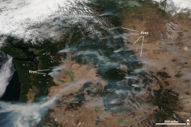
Suomi NPP satellite image taken of the western United States on September 2, 2017 using the VIIRS instrument. The smoke from multiple fires burning across the region is visible. NOAA Climate.gov image using data provided by the NOAA Environmental Visualization Laboratory.
While Texans were assessing the damage wrought by Hurricane Harvey, and the Southeast was eyeing Major Hurricane Irma, the western half of the country was suffering through record-breaking heat and skies filled with smoke from numerous wildfires burning all across the West.
In [the above] satellite image taken on September 2, numerous wildfires can be seen dotting the landscape across the Mountain West and along the West Coast. As of September 6, there were 65 ongoing fires across the United States according to the National Interagency Fire Center, all of which were located in the western United States and sending smoke into the air, reducing visibilities and blocking the sun.
In fact, a fire in the Columbia River Gorge in Oregon has spread smoke across the Pacific Northwest with some cities like Seattle and Portland even dealing with falling ash.
The Associated Press reported that the last time locals could remember ash falling from the sky was when Mount St. Helens [volcano] erupted in 1980.
In Montana, 23 fires are currently ongoing across the state and have already burned over 400,000 acres. The largest is the Rice Ridge fire which has burned over 100,000 acres and is only 2% contained.
Meanwhile, outside of Burbank, California, the La Tuna fire has become the largest on record for a wildfire within the city limits of Los Angeles. It has burned through over 7,000 acres and created scenes that look like they were taken during the filming of a disaster movie.
The smoke from these fires didn’t just stay put across the west. Instead, it hitched a ride along the jet stream—area of fast moving winds high in the atmosphere—and traveled with the winds across the United States. In this satellite image taken on September 4 [see website], smoke from western fires is visible being extended across the country, becoming intertwined with clouds as it gets stretched like a piece of saltwater taffy.
A dry, hot summer across the western United States is the reason for a fire-filled start to September.
[Graphic: U.S. Drought Monitor on August 29 showing regions of drought or abnormal dryness in the USA]
Aided by a large high pressure system, which has reduced clouds and allowed for scorching hot temperatures, the below-average rains and hot temperatures have helped provide the fuel for these wildfires. All that was needed was a spark, from either lightning or human activity. And for many places across the west, a spark was found.
[END REPORT]October
After rain deluges in California had raised up miles of brush, then came heat waves that turned all that brush to bone-dry tinder. Then came the annual winds, called "Diablo" in the state's north and "Santa Ana" in the south.
By early October alarms were sounding:
.... the California Department of Forestry and Fire Protection (CAL FIRE) had begun issuing red flag warnings throughout much of northern California as conditions were expected to become extremely volatile, with winds expected to be gusting between 25 to 35 miles per hour (40 to 56 km/h) from the north to the south.But nobody was prepared for what happened next:
By the evening of Sunday, October 8, the Diablo winds were reported gusting up to 70 miles per hour (110 km/h) within the affected areas ...Southern California was also struck by wildfires driven by the high winds but in the north, in the state's famous wine vineyard country, a nightmare began as the gale-force winds snapped electrical power lines, showering sparks on all those miles of dry brush.
Within moments more than a dozen wildfires broke out almost simultaneously in widely different areas. With blinding speed the outbreaks morphed into fast-moving infernos that killed every living creature and burned down virtually every structure in their path.
Who lived and who died in the path of the firestorms could be measured in split-seconds. A couple of tourists at a hotel, on learning that a wildfire was nearing, began to pack their suitcases. They were told there was no time to pack. There was only time to run.
By Saturday October 14 The Sacramento Bee was reporting that the human death toll from the northern California fires was at 39, with more bodies expected to be found; at least 5,700 structures had burned down; and 10,000 firefighters were battling wildfires under conditions so perilous they had to plan their own escape routes if they couldn't outrun a sudden shift in wind-driven flames.
At 2:30 this morning, Eastern Time, Reuters reported:
... Fast-moving fires spread by shifting winds forced thousands more to evacuate their homes on Saturday as the death toll over the week rose to 40, with hundreds missing.
More than 10,000 firefighters supported by air tankers and helicopters battled 16 major wildfires in areas north of San Francisco that have consumed nearly 214,000 acres (86,000 hectares), or roughly 334 square miles (865 sq km) -- an area larger than New York City.
[...]
“This is truly one of the greatest tragedies that California has ever faced. The devastation is just unbelievable. It is a horror that no one could have imagined,” California Governor Jerry Brown said on a visit to a devastated city. ...Meanwhile, back in central Portugal
The Telegraph Video, October 9:
As Portugal is battling another wave of wildfires with temperatures still high, a rare phenomenon known as a "fire devil", a kind of fire tornado, was caught on video camera Saturday evening by Portuguese broadcaster TVI. [video]
********As Portugal is battling another wave of wildfires with temperatures still high, a rare phenomenon known as a "fire devil", a kind of fire tornado, was caught on video camera Saturday evening by Portuguese broadcaster TVI. [video]


No comments:
Post a Comment